The Land and People Lab
The Land and People Lab is TPL’s “think and do” tank that advances TPL’s work through the power of evidence. From geospatial science to ecology, from economics to epidemiology, from social science to urban planning — we collect and analyze data, generate evidence, and get that evidence where it needs to go to influence policy and practice — all with the aim of advancing TPL’s strategic commitments to health, equity, climate action, and community.

We can support your organization’s goals with data and evidence-driven solutions.
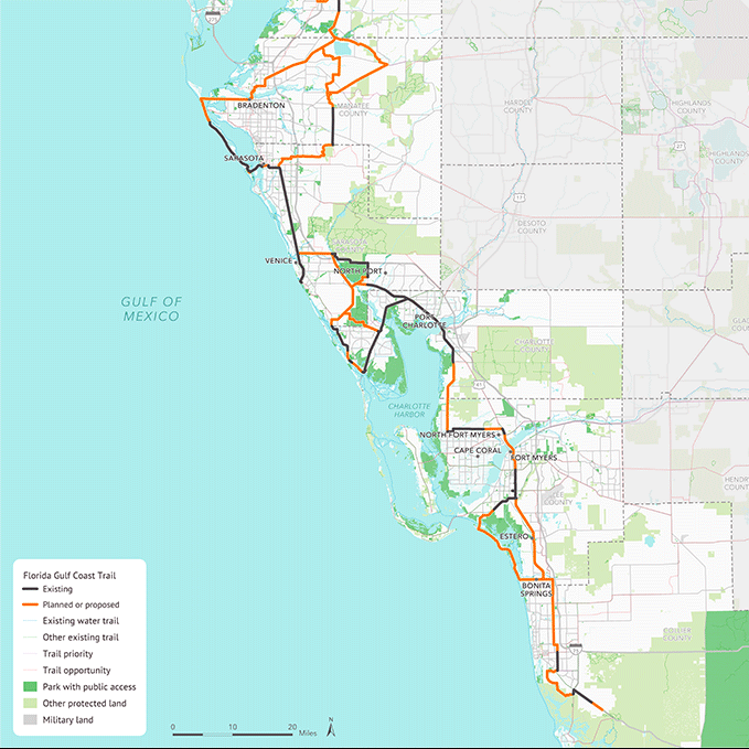
Trust for Public Land’s award-winning Geospatial Team has been around for over 20 years. We help TPL and external clients to strategically identify areas to create parks or protect land for people. From nationwide analyses to community-level prioritization, our team:
- Creates beautiful maps and story maps
- Houses sophisticated analyses in custom web-based decision-support tools
- Analyzes the impact of proposed policies and plans
We are experts in
- Spatial analysis & cartography
- National, regional, and local datasets
- Convening stakeholders to inform our analyses
- Ensuring our data and deliverables are actionable and accurate

We identify trends and conduct analyses to improve practices on the ground and inform policies that govern land use decisions.
- Park equity analysis
- Data solutions related to park quality, visitation and perceptions
- Economic benefits of park systems
- Return on investment of conserved lands
Active Projects:
- Economic benefits of East Baton Rouge Parish park system
- Park visitation patterns for a city park system using large scale anonymized mobility datasets


We work alongside communities to support informed decisions about how to grow while advancing equity, promoting health, addressing the climate crisis, strengthening communities—through such benefits as recreational opportunities, disaster resilience, clean air and water, economic opportunity, and safety.
- Greenprints and community planning
- Parks and open space master plans
- Custom ParkScore and 10-minute walk analyses
- Strategies for small towns and rural communities
- State Comprehensive Outdoor Recreation Plans (SCORP)
Active Projects:
- New Jersey State Comprehensive Outdoor Recreation Plan
- Statewide Planning for the Pennsylvania Dept of Conservation and Natural Resources
- New Bedford, MA Cultural Conservation Plan

We facilitate the use of rigorous evaluation to assess outcomes, improve performance, and drive impact.
- Program and project evaluation
- Impact metrics
- Mixed methods data collection and measurement
Active Projects:
- Leveraging community programs within parks to combat polarization, racism, and oppression
- Developing an evaluation framework for the Parks, Trails and Green Design focus area for the Ralph C. Wilson, Jr. Foundation
- Evaluating the outcomes of TPL’s Community Schoolyards initiative

Whether you want help closing the outdoor equity gap or planning a new park, need guidance about green infrastructure, or seek insights about the value of conserved lands, our experts are ready to work with you.


Sort By


The Lab is privileged to have the support and expertise of a group of individuals with expertise in community and environmental health, geospatial science, and urban planning.


How Can We Help?
Do you have a question about The Land and People Lab? We’re glad you’re interested in helping us connect everyone to the outdoors. Tell us how we can support you or your organization.
Give us a few details and we’ll get back to you soon.