Take it “SLO” along the Central California Coast
Take it “SLO” along the Central California Coast
San Luis Obispo—or SLO, as it’s known to locals—is a town of about 50,000 people tucked into the rolling hills on the Central California Coast. Halfway between San Francisco and Los Angeles, it’s a world away from any big city, with a laid-back, outdoorsy vibe all its own. After work, residents can hit the trails on 7,000 acres of city-owned open space, or cruise west along Highway 1 to a string of spectacular parks at Morro Bay.
For years, we’ve been helping San Luis Obispo residents protect the mountains and beaches of their beautiful backyard for everyone to explore. Whether you’re after pounding surf or a peaceful bay shore, flowing mountain biking trails or a relaxing stroll through an oak woodland, you’ll find something to love in San Luis Obispo County.
Take a pedal-powered excursion to the Irish Hills
Boasting a 10-mile trail system just minutes from downtown San Luis Obispo, the Irish Hills Natural Area is a mountain biker’s dream. (It gets its name from the look of the hillsides after the winter rains: a brilliant green evoking the lush Irish countryside). Following the Ocean View Trail, you’ll start with a steep climb out of Froom Creek—but soon you’ll be taking in sweeping views of the surrounding mountains and Morro Bay from long, rolling ridges. Today, the Ocean View Trail ends at a locked gate, but not for long: The Trust for Public Land recently helped the City of San Luis Obispo add more than 150 acres to the Irish Hills. When the new addition opens to the public, it will include the last link needed for a long, bike-accessible loop trail.
 SLO riders and hikers know that steep climbs in the Irish Hills yield rewards like this one, from the top of the Froom Trail.Photo credit: Rob DeGraff
Stroll through shady forests at Three Bridges Oak Preserve
You can be one of the first to enjoy the brand-new trails at the Three Brides Oak Preserve near the inland town of Atascadero. The multi-use trail system opened to the public on June 30—the culmination of years of effort by The Trust for Public Land to help Atascadero locals protect open spaces close to home. Hikers, bikers, and equestrians can all enjoy a shady two-mile loop trail in the lower half of the preserve. Hikers seeking higher ground can aim for the four-mile loop hike with nearly 700 feet of elevation gain: the trail starts in the cool streamside forest along Atascadero Creek, then climbs through oak-shaded grasslands and groves of madrone trees to a series of vista points, where you’ll be rewarded with views of the Salinas River Valley, the Santa Lucia Mountains, and the Temblor Mountains.
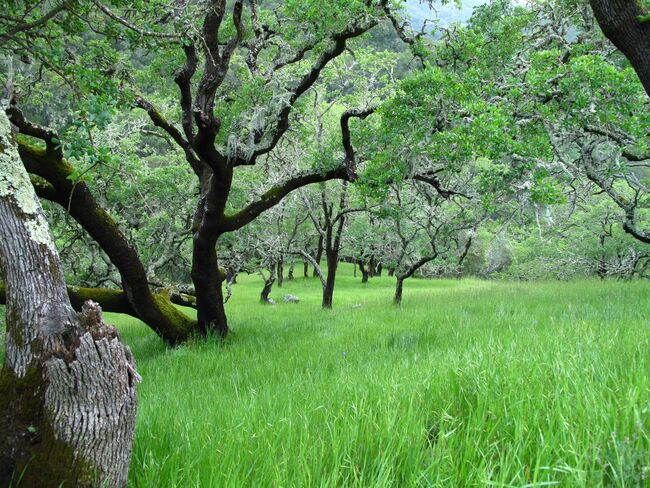 A brand-new trail system at Three Bridges Oak Preserve offers hikers a shady stroll when summertime temperatures soar. Photo credit: Brendan Moriarity
Get your feet wet at Estero Bluffs State Park
Do you know your anemones from your sea cucumbers? Your nudibranchs from your chitons? These are just a few of the wacky, colorful creatures that thrive in the rocky intertidal zone at Estero Bluffs State Park. The Trust for Public Land helped protect this stretch of coastal prairies, cliffs, and beaches near the small town of Cayucas: once slated for a subdivision, it instead became a new state park. Trails along the bluffs reveal panoramic views up and down the coast (this spot is a local favorite for watching the sunset), and if you make it to the water’s edge when the surf is calm and the tide is out, you can spend hours investigating the tidepools. For safe, leave-no-trace exploring, just be sure you wear shoes with solid, grippy soles and walk on bare rock instead of slippery mussel beds. And always keep an eye on the waves!
Chase the waves to Pideras Blancas
Follow Highway 1 up the coast to San Simeon and the famously over-the-top grandeur of Hearst Castle, which became a state park following the death of the newspaper magnate William Randolph Hearst. The coastline here was once a long stretch of private property, with no safe turnouts for drivers to take a break and take in the scenery—and no easy way down to the beach. But with help from The Trust for Public Land, California State Parks acquired 20 acres of coastal bluffs north of Point Piedras Blancas. The project created opportunities for hiking trails to the lighthouse on the point, plus new access to beaches and surf breaks.
 North of Point Piedras Blancas, 20 acres of public coastline make it twice as easy to Hang 10. Photo credit: Marlin Harris
Stretch your wings at Morro Bay
Sheltered from the powerful Pacific by a long sandbar, Morro Bay is a peaceful place for a day of paddling. To help ensure clean water quality in the bay, we protected a 580-acre wildlife preserve on the banks of Chorro Creek—one of the main tributaries feeding into the bay. You can rent kayaks across the road from the campground at Morro Bay State Park, then make your way south through the mouth of Morro Creek toward Sweet Springs Preserve, which The Trust for Public Land helped expand in 2008. Make sure to bring your binoculars: the saltwater wetlands harbor a rich diversity of migratory and resident birds that ranks Morro Bay among the Audubon Society’s top places in the country for birding. Keep an eye out for peregrine falcons that swoop around Morro Rock, the 581-foot-tall volcanic outcropping at the northern end of the bay. You can also paddle out to Morro Strand State Beach—but steer clear of areas closed to protect nesting grounds for the endangered snowy plover.
 At 581 feet, Morro Rock is the shortest of the Nine Sisters, a cluster of volcanic peaks around San Luis Obispo.Photo credit: Rich Ried
Rope up at Cerro Cabrillo
Cerro Cabrillo is a high, rocky ridge that rises to the east of Morro Bay. It’s one of the Nine Sisters—a string of 20-million-year-old volcanic peaks around San Luis Obispo (Morro Rock is the shortest, while nearby Bishop Peak soars above 1,500 feet). A hiking trail managed by Morro Bay State Park offers easy access for rock climbers to fun and varied routes for all skill levels—anchors are easy to access, and there are more options for beginners here than at other local crags. If you can take your eyes off the route, you’ll be rewarded with stellar views out over Morro Bay.
That San Luis Obispo County still offers so much open space is thanks in no small part to supporters of The Trust for Public Land—that’s people like you! With so many places to explore—and so many ways to do it—the hardest part about visiting might be deciding where to start. If you’ve got recommendations to share, leave a comment or head over to Facebook and tell us about your favorite San Luis Obispo spot.


Donate to become a member, and you’ll receive a subscription to Land&People magazine, our biannual publication featuring exclusive, inspiring stories about our work connecting everyone to the outdoors.
See how our supporters are helping us connect people to the outdoors across the country.