
Protecting the Places That Tell America's Story
From sacred Indigenous sites to awe-inspiring natural wonders, national monuments connect us to our history and each other. Together, we are working to protect these irreplaceable lands.
National monuments are lands that have been permanently protected because of their cultural, historic, or scientific significance. There are currently more than 100 national monuments in the United States, with the vast majority managed by the National Park Service.
TPL advocates for the creation of new national monuments and the expansion of existing ones.
Presidents using the Antiquities Act or Congress can designate monuments to protect public lands.
They safeguard lands of cultural, historical, ecological, or spiritual significance.
Monuments honor our cultural heritage, preserve biodiversity, and provide public access to nature.
TPL has contributed to the protection of more than 6,800 acres of national monuments, visited by millions of people annually, as they connect to nature, experience cultural treasures, and enjoy the outdoors.
How do we do this? We work in coalition with partner organizations. Together, we’ve helped generate thousands of petition signatures and letters of support for creating new national monuments. Frequently, we circle back after a monument is created to improve public access by protecting adjacent lands.

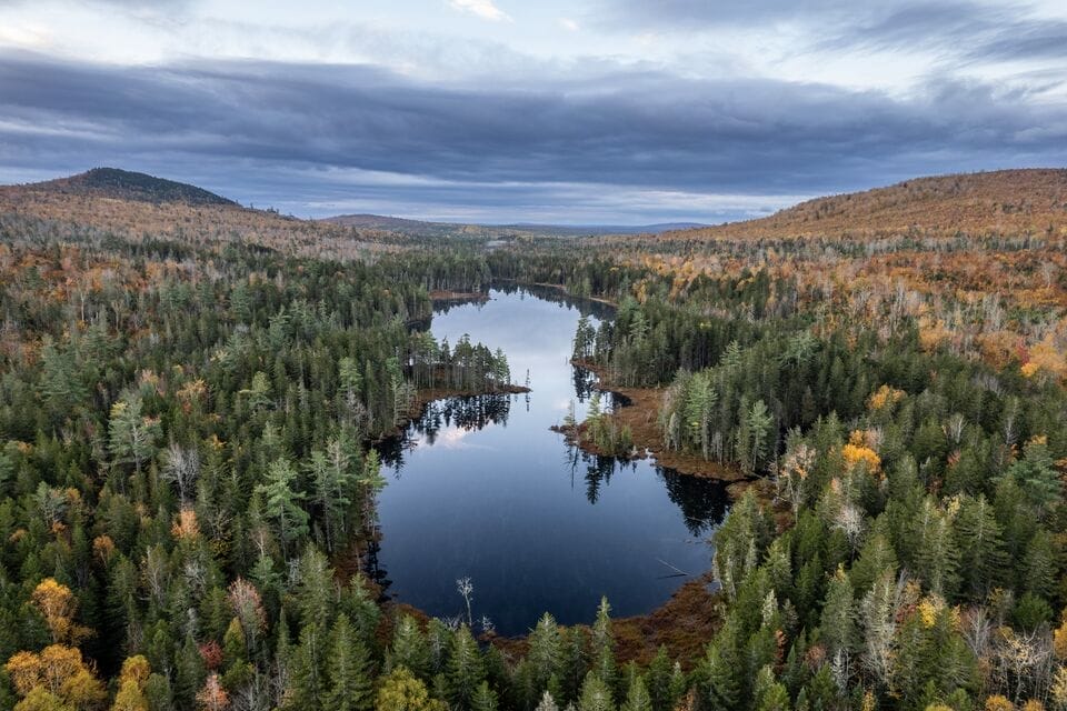
State: New Mexico (north-central)
Acreage: 242,000
Created: March 25, 2013
In the field, we look for ways to protect land adjacent to existing national monuments. The most recent example is Rio Grande Del Norte National Monument. With its deep gorges, volcanic cones, grassy plains and mountain peaks, Rio Grande del Norte National Monument offers both stunning scenery and outdoor recreation. Its diverse habitats are home to elk, mule deer, and bighorn sheep, as well as predators like cougar and black bears. Trust for Public Land has worked to protect these picturesque landscapes for years, and cheered the monument’s creation by President Obama. In the past two decades TPL has completed ten land acquisition projects in and around the monument, protecting 25,000 acres and creating new trailheads and improved access points. Our latest victory: on May 30, 2024, we conserved 3,700 adjacent acres of land at the southern end of the monument, conveying the property to the Bureau of Land Management, which owns and operates the national monument. The parcel, located next to the Taos Valley Overlook, features critical wildlife habitat and important recreational opportunities.
“It’s essentially along the highway, so it will create a great public access point,” says Myke Bybee, TPL’s senior director of government relations for land protection.
Another parcel adjacent to the monument is slated for protection later in 2024.
State: Maine (north-central)
Acreage: 87,563
Created: August 24, 2016
This expansive treasure, located about 200 miles northeast of Portland, boasts dense forests, rushing rivers and wildlife ranging from moose and black bear to bald eagles and bobcats. The national monument borders Baxter State Park, which includes Mount Katahdin, the highest peak in Maine, at 5,269 feet. It was created by President Obama and its origin has an interesting tie to Trust for Public Land. Lucas St. Clair, who chairs TPL’s National Board, is president of the Elliotsville Foundation, Inc., which donated all of the land for the national monument to the National Park Service. In the fall of 2023, TPL announced a plan that would greatly improve access to the national monument. The plan is part of an innovative tribal “land back” project that will restore nearly 30,000 acres to the Penobscot Nation while at the same time creating vitally needed southern access to the national monument on roads through the property.
When completed, the effort will represent the largest land return in American history between a U.S.-based nonprofit and a tribal nation.
Importantly, while the Penobscot Nation will be legal stewards of the land, known as Wáhsehtəkʷ, the project will allow the public to use certain roads on the property, thus creating new and much-needed southern access to the Katahdin Woods and Waters National Monument. Given its close proximity to the national monument, Wáhsehtəkʷ has long been a key puzzle piece in providing easier access for the communities of Millinocket, East Millinocket and Medway. Trust for Public Land expects to make the roads available for the National Park Service to create the southern access.
“It will make it a 30-minute drive instead of more than an hour,” explained Myke Bybee, , TPL’s senior director of government relations for land protection, adding that the communities were eager for the economic development potential of quicker access.

State: California (west)
Acreage: 7,924
Created: January 11, 2000
Expanded: March 11, 2014 and January 12, 2017
Situated along the entire length of the state’s 1,100-mile coastline, the California Coastal National Monument protects islets, reefs and rock outcroppings within 12 nautical miles of shore. There are believed to be 20,000 such outcroppings, which together provide critical habitat for marine-dependent wildlife. Those include some 200,000 breeding seabirds and thousands of marine mammals, from harbor seals to Steller’s sea lions. In addition, there are nearly 8,000 acres of public land on six onshore units: Trinidad Head, Waluplh-Lighthouse Ranch, Lost Coast Headlands, Piedras Blancas, Point Arena-Stornetta, and Cotoni-Coast Dairies. In 2014, TPL made a key addition to the 1,655-acre Point Arena-Stornetta expansion; three years later, we played a decisive role in adding the spectacular Cotoni-Coast Dairies, a seven-mile stretch north of Santa Cruz, to the monument.

State: Minnesota (southwest)
Acreage: 301
Created: August 25, 1937
Expanded: March 10, 2007
Pipestone National Monument is so-called because of its soft, red stone, which for more than 3,000 years has been quarried by Indigenous peoples for the purpose of making pipes used in prayer and ceremonies. It is a tradition that endures, with the site’s 56 quarry pits reserved for Native Americans enrolled in federally recognized tribes. Indeed, the quarries are considered culturally significant to nearly two dozen tribal nations across North America. In 2007, Trust for Public Land donated 15 acres of land adjacent to the national monument to the National Park Service. The addition prevented future development next to one of the monument’s signature attractions, Winnewissa Falls. It also allowed for the restoration of the native tall grass prairie that once dominated the region.

Presidents seem to like using their authority to designate monuments, with 16 of the last 18 occupants of the White House to do so.
Perhaps not surprisingly, Theodore Roosevelt, who was president in 1906, created the first 17 national monuments, starting with Devils Tower in Wyoming.
Indeed, many presidents have seen the Antiquities Act as a way to pursue their conservation agenda in the face of a recalcitrant Congress. President Barack Obama, for instance, created or expanded nearly three dozen national monuments, more than any other president.
His tenure included diminutive monuments like Stonewall in New York’s Greenwich Village. The 7-acre Stonewall National Monument, centered on Christopher Park, is across the street from the Stonewall Inn, where an uprising following a 1969 police raid helped spark the gay rights movement and where the LGBTQ community today assembles for marches and parades.
Other monuments are, well, monumental. George W. Bush in 2006 established the Papahānaumokuākea Marine National Monument in Hawaii, with 89.5 million acres; President Obama greatly expanded it a decade later, adding 283 million acres.
Presidents and Congress have also used the Antiquities Act to modify, diminish, or abolish monuments, and President Donald Trump used the act twice to reduce Bears Ears and Grand Staircase-Escalante.