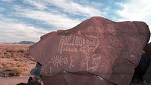
Sears Point

For thousands of years, humans have left their mark on the black basaltic mesas along the Gila River, At the site now known as Sears Point, prehistoric peoples and Native Americans created petroglyphs and astrological sites. The rocks also bear signs of Spanish settlers, stagecoach passengers, and frontier land surveyors. Sears Point’s colorful past has earned it a listing on the National Register of Historic Places-and inclusion on the Juan Bautista De Anza National Historic Trail and Butterfield Overland Mail Route.
Despite the significance of Sears Point, the fact that much of the land here was under private ownership meant that many of its cultural artifacts were vulnerable to theft and vandalism. The Trust for Public Land helped conserve 225 acres at Sears Point for the Bureau of Land Management, ensuring better protection for historic artifacts and creating new opportunities for interpretative trails, camping facilities, and improved public access to this unique cultural resource.

